PENNSVALLEY
98
COPYRIGHT
Southern Africa
Lesson 50:
Political Features of Southern Africa
Southern Africa is the final region in Africa that we will study. Southern Africa includes 13 countries.
Tencountriesarepart ofmainlandAfrica.Threecountriesare islandnations lyingoff theeasterncoastline
of Mozambique in the IndianOcean.
Madagascar
is Africa’s largest island nation and the world’s fourth
largest island. About 500 miles east of Madagascar is the small island nation of
Mauritius
. Between
mainland Africa and the northwestern tip of Madagascar are three islands that make up the nation of
Comoros
. A fourth island is part of theComoros archipelago but remains under French control.
Southern Africa has valuable mineral resources. Countries in Southern Africa are some of the
world’s leading producers of gold, diamonds, uranium, copper, and coal. Like other parts of Africa, the
potential of mineral resources and economic development has been slowed because of civil wars and
political unrest.
ACTIVITY 1:
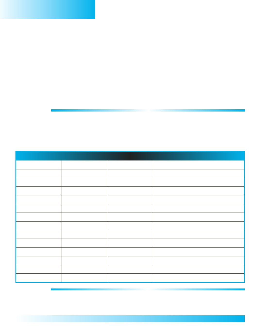
The name of each country in Southern Africa and its capital city are listed in the table below. 1) Use
thegrid coordinates in the table to locate the countries on the regional mapof Africaon thenext page.
2)Write thenameof the country in the spaceprovidedon themap.3) Label each country’s capital city
at the starred location on the regional map.
After you have located and labeled each country and its capital city, use a colored pencil to trace
each country’s boundary.Use your political map of Africa in your classroom atlas as a resource.
Regional Table
Country
GridCoordinate
Capital City
Weather
Comoros
E/F, 2/3
Moroni
Madagascar
F, 3/4
Antananarivo
Mauritius
G, 3
Port Louis
Mozambique
D, 3/4
Maputo
Malawi
D, 2
Lilongwe
Zambia
C, 3
Lusaka
Angola
B, 2
Luanda
Namibia
B, 3/4
Windhoek
Botswana
C, 4
Gaborone
Zimbabwe
D, 3
Harare
Swaziland
D, 4
Mbabane
Lesotho
D, 5
Maseru
SouthAfrica
C/D, 4/5
Pretoria
ACTIVITY 2:
Using the Internet, research today’s weather for each capital city in Activity 1.Youmay write the type
of weather the city is experiencing or draw a weather symbol for each city in the blank space of the
fourth
column of your
RegionalTable
inActivity 1.


