PENNSVALLEY
94
COPYRIGHT
Central Africa
Lesson 48:
Political Features of Central Africa
The ten countries of Central Africa surround the Equator.With the exception of Uganda, Rwanda,
and Burundi, much of Central Africa is dominated by the hot, humid rainforests of the Congo River
basin. Uganda, Rwanda, and Burundi lie on the western branch of the Great Rift Valley. Like many
other parts of Africa, the countries of Central Africa suffer from poverty and unstable governments.
AlthoughCameroon is one of themost ethnically diverse countries inAfrica, a stable government and
sound economic policies have developed valuable resources, and enabledCameroon to prosper.
ACTIVITY 1:
Let’s take a tour of the countries of Central Africa. Refer to your classroom atlas to learn where the
countries are located. A) Use the numbers in the table below to locate and write the names of the
countries in theblank spaces on your regional mapon thenext page.B) Next, use the letters to locate
and label each country’s capital city. Remember, please print neatly. C) After you have labeled your
regional map, find each country’s borders and trace themwith a colored pencil.
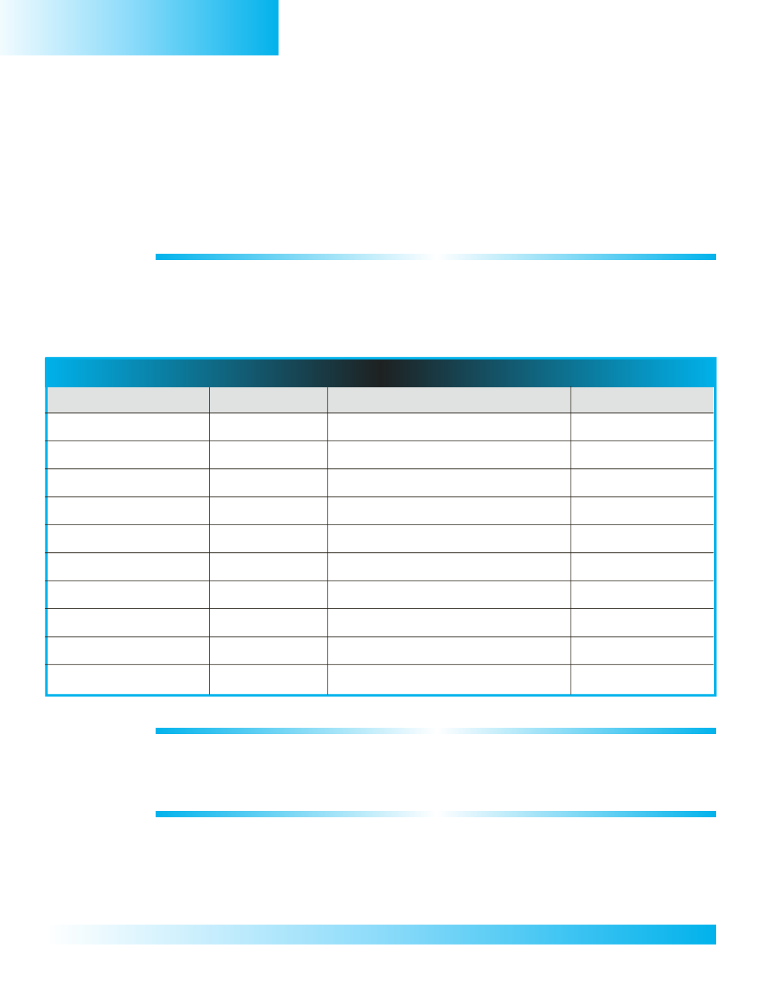
Regional Fact Chart – Central Africa
Country
Capital City
Today’sWeather
Physical Features
0
1.
Cameroon
a.
Yaounde
AtlanticOcean
0
2.
Equatorial Guinea
b.
Malabo
Equator
0
3.
SaoTome&Principe
c.
SaoTome
0
4.
Gabon
d.
Libreville
0
5.
Congo
e.
Brazzaville
0
6.
Central AfricanRep.
f.
Bangui
CongoRiver
0
7.
Dem.Rep. of Congo
g.
Kinshasa
CongoBasin
0
8.
Uganda
h.
Kampala
Rift Valley
0
9.
Rwanda
i.
Kigali
LakeVictoria
10.
Burundi
j.
Bujumbura
LakeTanganyika
ACTIVITY 2:
Using the Internet, research today’s weather for each capital city.You may write the type of weather
the city is experiencing or draw aweather symbol for each city in the blank space of the third column
of your chart.
ACTIVITY 3:
To help us learnmore about the countries of Central Africa, let’s review some of the important physical
features that influence the climate and lifestyles of the people in this region (
LLB=Lesson 40 & 42
).
Refer to thephysicalmapof Africa inyour classroomatlas to locate thephysical features listed incolumn
four of your Regional Fact Chart. Label each political feature on the regional map on the next page.


