PENNSVALLEY
90
COPYRIGHT
Western Africa
Lesson 46:
Political Features of Western Africa
Western Africa includes thirteen independent countries. Twelve countries are part of mainland
Africa. CapeVerde is a group of islands off the western tip of Senegal.Western Africa has a rapidly
growing population of more than 230million people.Nigeria, withmore than 112million people, is the
most populated country on theAfrican continent and the ninthmost populated in theworld.
WesternAfrica includesmanydifferent groupsof people, or ethnicgroups, withdifferent languages
and traditions. Many of these ethnic groups have been strongly influenced by powerful tribes and
empires such as the Akan, Mali, Malinke, and Mandinke. Nigeria alone has more than 250 different
ethnic groups. Cote D’Ivoire (Ivory Coast) has 60 tribal groups. In addition to the native people, or
indigenous people, a largenumber of European settlers fromGreat Britain, France, andPortugal were
attracted toWesternAfrica during the late 1800s by gold and other natural resources.
Guinea, Guinea Bissau, Sierra Leone, and Burkina are four of the poorest countries in the world.
Educational opportunities are limited for children.As a result, adult literacy rates are very low.
Literacy
is
the percentage of people over 15 years of agewho can read andwrite.ThroughoutWestern Africa less
than 40 percent of adults can read and write. In Sierra Leone, Guinea, and Burkina, only 25 percent of
adults readandwrite.Compare these countries to theUnitedStateswhereadult literacy isat 99percent.
Health care is very limited and many children and adults never get to see a doctor. Throughout
Western Africa there are nearly 20,000 people for every one doctor. International organizations have
placedagreat deal of effort on immunizingchildren toprevent disease, butmuchmorework isneeded.
Over the past thirty years, the terrible disease of AIDS has spread throughout Africa at an alarming
rate. Today, the life expectancy of people living inWestern Africa is less than 50 years. The average
person in theUnitedStates lives 74 years.
ACTIVITY:
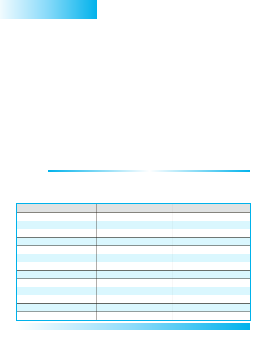
The countries and capital cities ofWesternAfrica are listed in the chart below. 1) Use the numbers in
the chart tohelp you locateandwrite thenameof each country on the regional mapon thenext page.
2) Next, locate and label each country’s capital city in the chart. 3) After you have located and labeled
the countries and capital cities, use colored pencils to trace the borders of the countries that make up
NorthernAfrica.Use the political map of Africa in your classroom atlas as a resource.
Country
Capital City
Climate/Weather
0
1.CapeVerde
Praia
0
2. Senegal
Dakar
0
3.Gambia
Banjul
0
4.GuineaBissau
Bissau
0
5.Guinea
Conakry
0
6.CoteD’Ivoire (IvoryCoast)
Yamoussoukro
0
7. Sierra Leone
Freetown
0
8. Burkina
Quagadougou
0
9.Ghana
Accra
10.Togo
Lome
11. Benin
Porto-Nova
12.Nigeria
Abuja
13. Liberia
Monrovia


