PENNSVALLEY
130
COPYRIGHT
Southeast Asia
Lesson 66:
Political Features of Southeast Asia
To give you an idea of the size and location of Southeast Asia, look at Lesson 54, Geographical
Regionsof Asia
(LLB=Lesson54)
.Therearea total of 11 countries in this region.These countriesare
divided into two groups. One set of countries is located on mainland Asia bordering China. Another
name for this cluster of countries is Indochina.
The other set of countries is located in what is called maritime Asia. Maritime means that island
and archipelago countries are situated close to the sea.This group of countries is also called Insular
Southeast Asia. Insular means a group of islands not connected physically to the other countries of
Asia.
Southeast Asia extends from the foothills of the HimalayaMountains to south of the Equator.The
Equator passes through Indonesia.
ACTIVITY 1:
Let’s takea tour aroundSoutheast Asia.Use your classroom school atlas to learnwhere the countries
are located. Part A1) Use the grid coordinates to locate and write the names of the countries in the
blanks on your regional map on page 132. Part A2) After you have located and labeled each country,
find its borders and trace themwith colored pencils, crayons, or markers.
Part B) Use the grid coordinates to locate and write the names of the capitals for each country in
the blanks on your regional map on page 132.
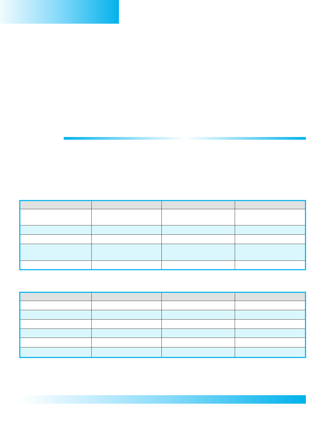
Part A
MainlandCountries
Part B
GridCoordinates
Country’sName
GridCoordinates
Country’sCapital
B,1/2
Myanmar
B,2
Rangoon
( also calledBurma)
B/C,2/3
Thailand
C,3
Bangkok
C,2
Laos
C,2
Vientiane
C/D,3
Cambodia
C,3
PhnomPenh
(also calledKampuchea)
C/D,2/3
Vietnam
D,2
Hanoi
Part A
MaritimeCountries
Part B
GridCoordinates
Country’sName
GridCoordinates
Country’sCapital
C,4&E,4
Malaysia
C,4
Kuala Lumpur
C,4
Singapore
C,4
SingaporeCity
E,4
Brunei
E,4
Bandar Seri Begawan
B/C/D/E/F/G/H/I,4/5/6 Indonesia
D,6
Jakarta
G,6
East Timor
G,6
Dili
F/G,2/3/4
Philippines
F,3
Manila


