COPYRIGHT
123
PENNSVALLEY
Lesson 63:
Political Features of South Asia
To give you an idea of the size and location of South Asia, look at Lesson 54, Geographical
Regions of Asia. South Asia also is called the Indian subcontinent because the country of India is
separated from the rest of Asia by the Himalaya Mountains to the north. There are seven countries
located in this region of Asia.
India is a large peninsula that occupies much of the subcontinent. In land area, India is about
one third the sizeof theUnitedStates.However, withmore thanonebillionpeople, India is the second
most populated country in theworld.
Most of this regionwas under British ruleuntil 1947.The twomain countries of the region, India
andPakistan,weredividedalong religious lines. Indiawasset up for peopleof theHindu faith.Pakistan
was established for people of the Islamic faith.
ACTIVITY 1:
Let’s take a tour aroundSouthAsia.Use your classroom school atlas to learnwhere the countries are
located.Part A1) Use thegrid coordinates to locateandwrite thenames of the countries in theblanks
on your regional mapon thenext page.Part A2) After youhave locatedand labeledeach country, find
its borders and trace themwith colored pencils or crayons.
Part B) Use the grid coordinates to locate and write the names of the capitals for each country in
the blanks on your regional map on the next page.
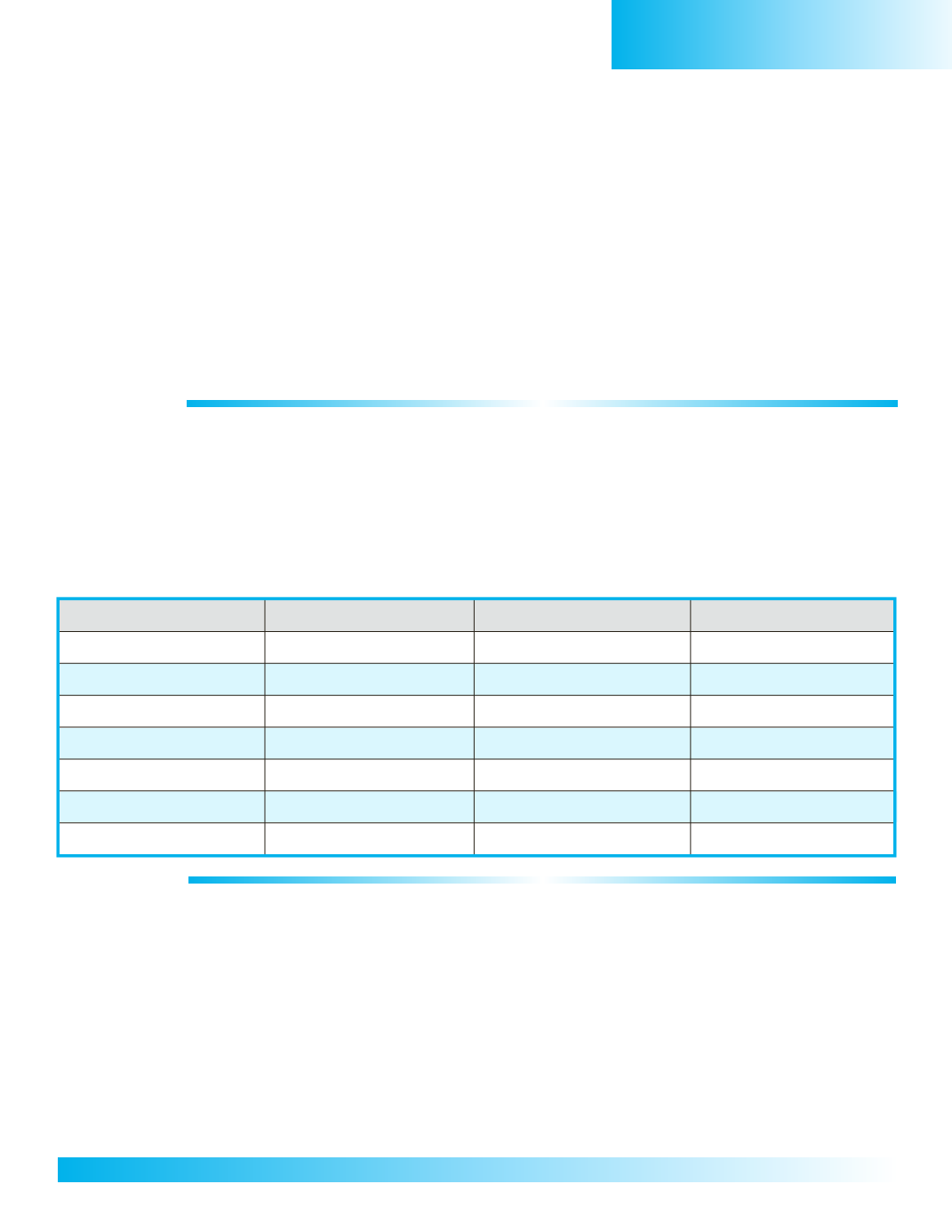
Part A
Part B
GridCoordinates
Country’sName
GridCoordinates
Country’sCapital
D,6
Maldives
D,6
Male
E,5
Sri Lanka
E,5
Colombo
D/E/F,3
India
E,2
NewDelhi
B/C,2
Pakistan
D,1
Islamabad
F,2
Nepal
F,2
Kathmandu
G,2
Bhutan
G,2
Thimphu
G,3
Bangladesh
G,3
Dhaka
ACTIVITY 2:
A)Use thegrid coordinates to locateandwrite in thenamesof other important citiesof SouthAsiaon your
regionalmapon thenext page.B)Then, use thegridcoordinates to locateand label theborderingcountries.
Karachi at C,3
Mumbai (Bombay) at D,4
Kolkata (Calcutta) at G,3
andChennai (Madras) at F,3
1. B,2 = Iran forms Pakistan’swestern border.
2. B/C,1/2 =Afghanistan forms Pakistan’s northwest border.
3. F/G, 2 =China formsmuch of SouthAsia’s north and northeastern borders.
4.H,3/4 =Myanmar (Burma) forms India’s eastern border.
South Asia


