PENNSVALLEY
110
COPYRIGHT
Southwest Asia
Lesson 58:
Political Features of Southwest Asia
(Middle East)
Another name for Southwest Asia is theMiddleEast.There are 18 countries located in this part of
Asia.Some are rather large, such asSaudi Arabia.Others are very tiny, such as the island of Bahrain
in thePersianGulf.
Thereare somenewcomer nations to this region.When the former Soviet Union collapsed in1991,
15 new nations claimed independence.Three of those nations areGeorgia, Armenia, andAzerbaijan.
The CaucasusMountain Range, which runs through these three countries, forms a division between
Europe andAsia.
This regionhasbeen troubledby conflict for centuries. It hasbeenhypothesized that thereare two
main reasons for this.One reason is this region is the birthplace of threemajor religions of theworld.
They are Judaism, Islam, and Christianity. People of different religious faiths do not agree on many
issues.
The second reason is that the region hasmany ethnic groups.Remember, ethnicity can deal with
race, religion, culture, anda senseof nation.When youdeal withall of these factors, youhave tension
and disagreement. And, a large ethnic minority with no homeland creates tremendous unrest and
conflict.
This regionwas ruled by the colonial empires of Europe for many years.When the former colonial
powers divided these places into countries, they did not consider the different ethnic groups. For
example, with an estimated 25 million people, the non-Arab Kurds are one of the largest ethnic
minorities without a homeland.TheKurdish people are locatedmainly in Iraq, Turkey, and Iran.
The Arab Palestinians are another large group of refugees without a country. Nearly 10 million
peopleare identifiedasPalestinian.Manyare found in Jordan, Israel, andSyria.Anagency calledThe
PalestinianAuthorityhasbeengranted someauthority toadminister somegoverning tasks in theWest
Bank and theGazaStrip.However, these areas are still controlled by Israel.
ACTIVITY 1:
Let’s take a tour around theMiddleEast, or Southwest Asia.Use your classroom atlas to learnwhere
the countries are located. A) Use the grid coordinates to locate and write the names of the countries
in the blanks on your regional map on page 111. B) After you have located and labeled each country,
find its borders and trace themwith colored pencils or crayons.
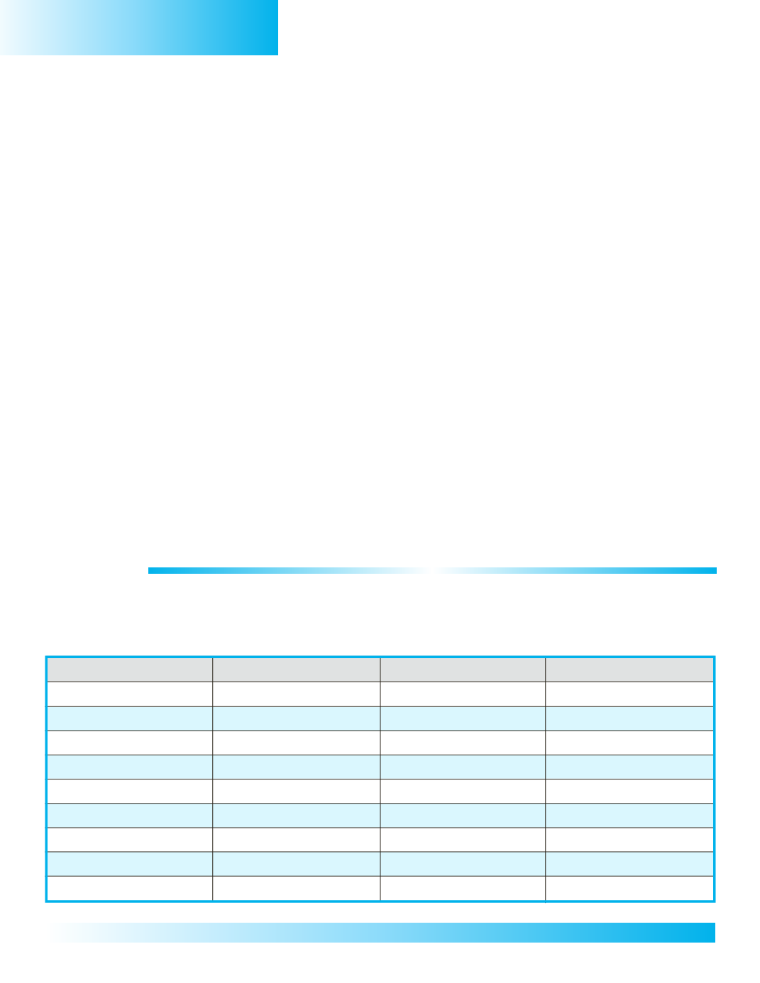
GridCoordinates
Country’sName
GridCoordinates
Country’sName
1.C/D, 1/2
Turkey
10.C,3
Israel
2. E,1
Georgia
11.C,3
Jordan
3. E,1
Armenia
12. F,3
Kuwait
4. F,1
Azerbaijan
13. E/F,4
Saudi Arabia
5.G/H,2
Iran
14.G,4
Bahrain
6. E,3
Iraq
15.G,4
Qatar
7.D,2
Syria
16.G/H,4
UnitedArabEmirates
8.C,2
Cyprus
17.H,5
Oman
9.C,3
Lebanon
18. E/F,5
Yemen


