COPYRIGHT
49
PENNSVALLEY
Lesson 26:
Political Features of Eastern Europe
and the Russian Federation
Our final region of study includes 8 countries of Eastern Europe and the western portion of the
Russian Federation, the largest country in the world. In the introduction to the continent of Europe
(LLB=Lesson 11)
you learned that the Russian Federation stretches across two continents, Europe
andAsia.You also learned that geographers refer to this combined land area as
Eurasia
.
Using the globe in your classroom, locate theRussian Federation. If youwould draw an imaginary
line from the western boundary of the Russian Federation eastward to the Bering Strait, you would
cover nearly half the globe.You would cross 11 time zones. The boundaries of
1. European Russia
are defined by twomountain ranges.The Ural Mountains, extending north to south, form the eastern
boundary. The Caucasus Mountains form the boundary in the southwest. Russia’s largest cities,
Moscow and Leningrad, and about two thirds of the population, are found in European Russia.
However, nearly 75 percent of Russia’s land area lies in the continent of Asia.
Our final region of study also includes eight countries located to thewest of EuropeanRussia. Six
of these countries were once states of the Soviet Union. They include
2. Estonia, 3. Latvia, 4.
Lithuania, 5. Belarus, 6. Ukraine,
and
7. Moldova
. In 1991, the communist-led government of the
Soviet Unionwent throughmajor political changes and these countries became independent nations.
After World War II,
8. Romania
and
9. Bulgaria
were strongly influenced by communism but
remained independent of theSoviet Union.Bulgariawas considered part of the eastern bloc of Soviet
nations.Romaniawas ruled by a harsh communist dictator. In 1989, Romania andBulgaria overcame
communism in favor of democratic forms of government.
ACTIVITY 1:
1) On the activity map on the next page, label the countries of Eastern Europe that are numbered and
boldfaced
above.Use thepoliticalmapofEurope inyour classroomatlasand the
InformationOrganizer
below as references. 2) Find each country’s capital in the organizer below. Label the capital city at the
starred locationon theactivitymap. 3)Traceeach country’s border usingadifferent coloredpencil.
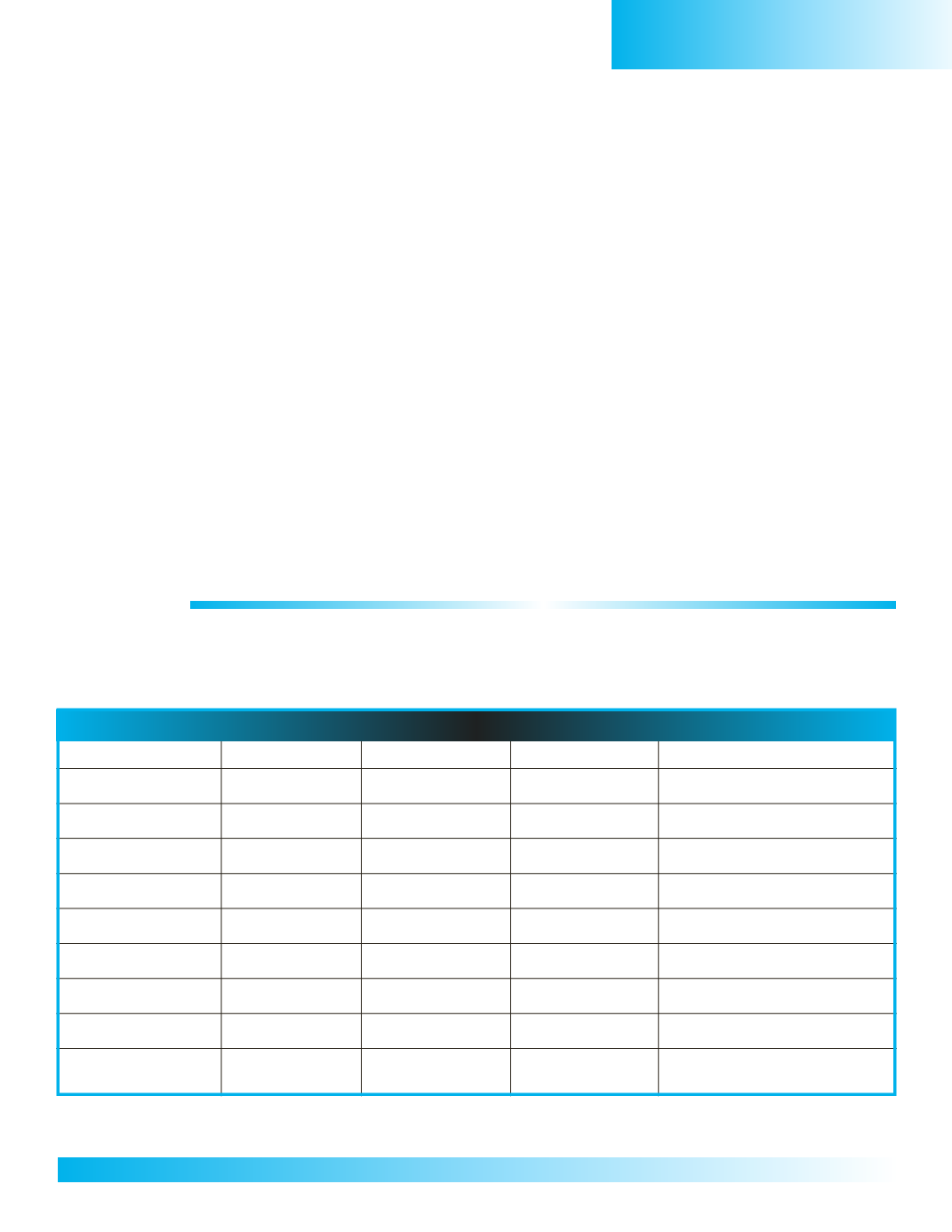
InformationOrganizer for Eastern Europe and the Russian Federation
Country
Capital City SquareMiles Population
Climate/Weather
Estonia
Tallinn
17,462
1,332,900
Latvia
Riga
24,938
2,290,200
Lithuania
Vilnius
25,174
3,596,600
Belarus
Minsk
80,154
10,300,500
Ukraine
Kiev
233,089
47,425,300
Moldova
Chisinau
13,067
4,455,400
Romania
Bucharest
91,700
22,330,000
Bulgaria
Sofia
48,822
7,450,350
RussianFederation Moscow
6,592,735*
146,900,000*
* Total Country
Eastern Europe


